Файл:NE_600ad.jpg
З Вікіпедії, безкоштовно encyclopedia
Повна роздільність (1439 × 1086 пікселів, розмір файлу: 502 КБ, MIME-тип: image/jpeg)
| Відомості про цей файл містяться на Вікісховищі — централізованому сховищі вільних файлів мультимедіа для використання у проектах Фонду Вікімедіа. |
Зміст
Опис файлу
| ОписNE 600ad.jpg |
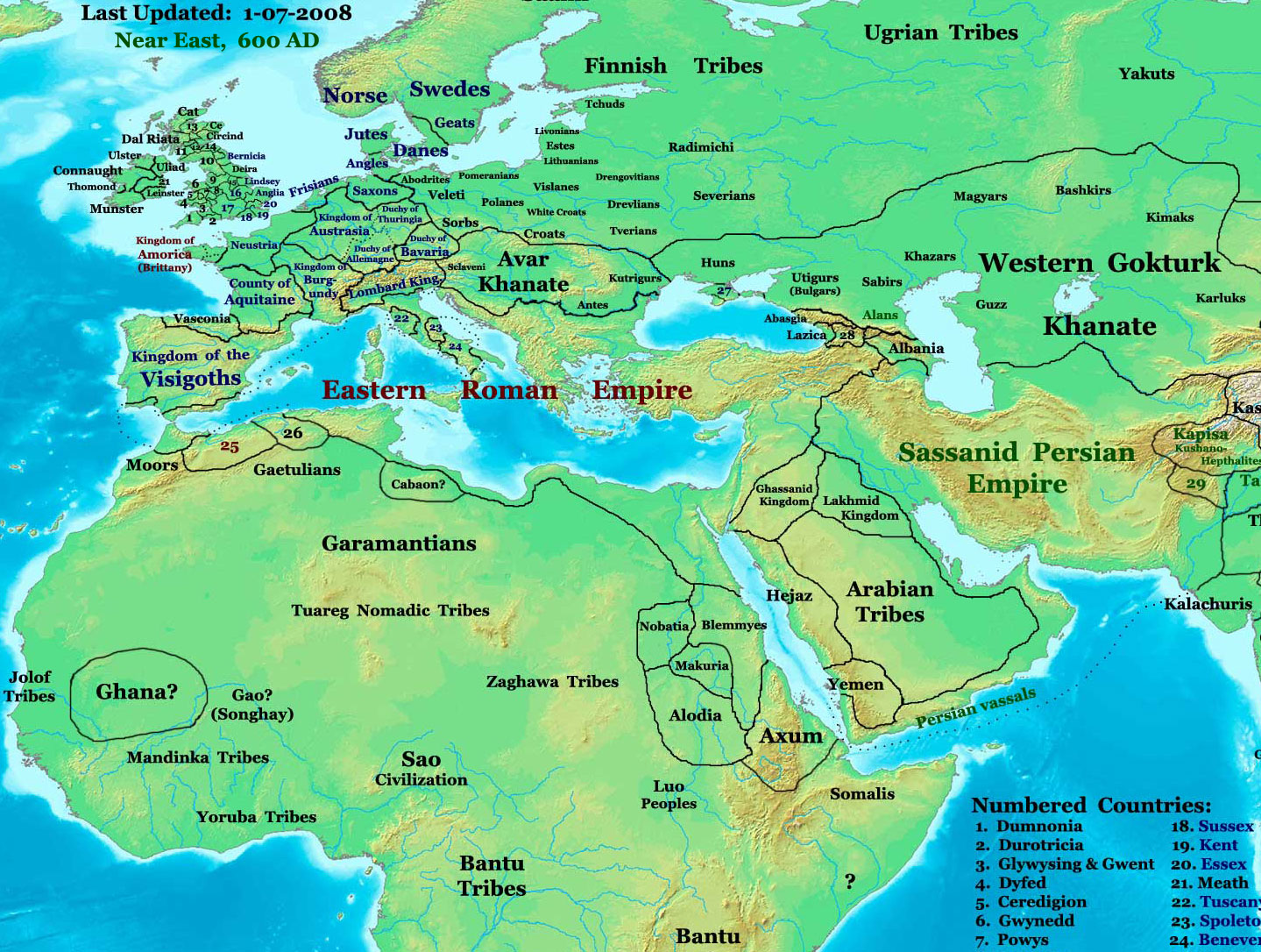
English: part of: Eastern Hemisphere in 600 AD.
Description: This image is a zoomed-in version of the Eastern Hemisphere in 600 AD. Author: Thomas A. Lessman (talessman@yis.us), later modified by others. Source URL: http://www.worldhistorymaps.info/images/East-Hem_600ad.jpg. Image Summary:Created by Thomas Lessman, based on this map of Eastern Hemisphere in 600 AD. Free for educational use. If you use this image, please credit the author (Thomas Lessman) and include (Source URL: http://www.worldhistorymaps.info/images/East-Hem_600ad.jpg). If you can help improve this map, please contact Thomas Lessman at talessman@yis.us. Other Historical Maps by Thomas Lessman
|
|||||||||||||||||||||||||
| Час створення | 17 січня 2008 (дата завантаження оригінального файлу) | |||||||||||||||||||||||||
| Джерело | Перенесено з en.wikipedia на Вікісховище. | |||||||||||||||||||||||||
| Автор | Talessman з англійська Вікіпедія | |||||||||||||||||||||||||
| Ліцензія (Повторне використання цього файлу) |
|
|||||||||||||||||||||||||
| Інші версії | Disputed map because the version with « Romanised Dacians » (= Olahok, Vlachs) and « Slavs » (Totok, Slavons, Slovens...) may be a romanian and slavic POV, but this « Only Avars and no other people north of the Danube, in the future Kingdom of Hungary », according to the Eduard Rössler's « Awarenwüste » theory, shows an Austrian-Hungarian POV: one is not more objective than the other and unfortunately no synthesis is possible. | |||||||||||||||||||||||||
Ліцензування

|
Дозволяється копіювати, розповсюджувати та/або модифікувати цей документ на умовах ліцензії GNU FDL версії 1.2 або більш пізньої, виданої Фондом вільного програмного забезпечення, без незмінних розділів, без текстів, які розміщені на першій та останній обкладинці. Копія ліцензії знаходиться у розділі GNU Free Documentation License.http://www.gnu.org/copyleft/fdl.htmlGFDLGNU Free Documentation Licensetruetrue |
| Цей файл ліцензований на умовах ліцензії Creative Commons Attribution-Share Alike 3.0 Unported | ||
| Зазначення авторства: Talessman at the English Wikipedia | ||
| ||
| Цей шаблон ліцензування був доданий до файлу в рамках оновлення ліцензії GFDL.http://creativecommons.org/licenses/by-sa/3.0/CC BY-SA 3.0Creative Commons Attribution-Share Alike 3.0truetrue |
| Maps of the eastern hemisphere showing history
Bold dates are available on Wikimedia or Wikipedia. | ||
| Primeval | ||
| Ancient
|
·| 600 BC | 550 BC | 527 BC | 500 BC |
400 BC | ·| 1 AD | 50 AD | 100 AD | 200 AD | 300 AD | | |
| Medieval |
·| 500 AD | 565 AD | 600 AD | 700 AD | | |
| Modern |
·| 1500 AD | · * For historical maps of the whole world, | |
| history links talk edit view | ||
·
Журнал завантажень локального файлу
- 2008-01-17 20:07 Talessman 1439×1086× (513542 bytes) Added more info for Africa, corrected some info on Europe.
- 2007-11-02 18:55 Talessman 1450×988× (440135 bytes) Corrected borders in Africa/Sudan and Arabia.
- 2007-10-31 20:30 Talessman 1429×927× (437106 bytes) Corrected borders of Ghana, made other names easier to read, other misc. corrections.
- 2007-10-21 00:19 Talessman 1251×779× (341469 bytes) Author: Thomas A. Lessman. Source URL: http://www.ThomasLessman.com/History/images/East-Hem_600ad.jpg. Image was created by me (Thomas Lessman) based on map of Eastern Hemisphere in 600ad. Image is free for public and/or educational use. I would appreciat
Підписи
Об'єкти, показані на цьому файлі
зображує
17 січня 2008
image/jpeg
Історія файлу
Клацніть на дату/час, щоб переглянути, як тоді виглядав файл.
| Дата/час | Мініатюра | Розмір об'єкта | Користувач | Коментар | |
|---|---|---|---|---|---|
| поточний | 16:54, 9 червня 2024 | | 1439 × 1086 (502 КБ) | OrionNimrod | Reverted to version as of 19:28, 26 September 2023 (UTC) restore original |
| 17:26, 7 березня 2024 |  | 1439 × 1086 (1,14 МБ) | Nihil scimus | Restored a more accurate map uploaded march 15, 2023 by Moodylo333: Armenia was not Byzantine (see Claude Murafian's & Eric Van Lauwe's ''Atlas historique de l'Arménie'', Autrement publ., ISBN 2746701006); Highlighted the boundaries of the Eastern Roman Empire, Sassanid Persia and the Göktürk Khanate; Drawn the Slavic perimeter and reduced the Avar perimeter (greatly exaggerated) according to [https://commons.wikimedia.org/wiki/File:Avar_settlement_area.jpg] and to Vladislav Popovic's «La des... | |
| 19:28, 26 вересня 2023 |  | 1439 × 1086 (502 КБ) | OrionNimrod | Reverted to version as of 09:20, 1 February 2009 (UTC) keep original | |
| 16:28, 15 березня 2023 |  | 1439 × 1086 (1,14 МБ) | Moodylo333 | More accurate map: see explanations. | |
| 13:38, 28 жовтня 2022 |  | 1439 × 1086 (502 КБ) | OrionNimrod | Reverted to version as of 09:20, 1 February 2009 (UTC) "Romance Dacians in 600" in Transylvania is clearly a Romanian nationalist POV, and there is Avar archeological sites, but the Avar territory was decreased in the updated map. Dacians in 600??? | |
| 15:47, 27 жовтня 2022 |  | 1439 × 1086 (744 КБ) | Nihil scimus | Modifications from academic historical books do not "invent nations" or falsifie Commons' digital incomplete maps, but enrich them. | |
| 17:29, 6 жовтня 2022 |  | 1439 × 1086 (502 КБ) | OrionNimrod | Reverted to version as of 09:20, 1 February 2009 (UTC) restored the original one which was extract from the big original map, the map was falsified with did not exist nations at that time 600 AD | |
| 12:55, 11 грудня 2014 |  | 1439 × 1086 (744 КБ) | Spiridon Ion Cepleanu | Garamantian & Arabic tribes areas | |
| 17:26, 20 листопада 2014 |  | 1439 × 1086 (742 КБ) | Spiridon Ion Cepleanu | Lakes & Caspian shorelines | |
| 13:21, 15 листопада 2014 |  | 1439 × 1086 (737 КБ) | Spiridon Ion Cepleanu | Add missing names: Altava, Warsenia, Iberia, Kaikanan |
Використання файлу
Такі сторінки використовують цей файл:
Глобальне використання файлу
Цей файл використовують такі інші вікі:
- Використання в ast.wikipedia.org
- Використання в az.wikipedia.org
- Використання в ba.wikipedia.org
- Використання в bg.wikipedia.org
- Використання в ca.wikipedia.org
- Використання в cv.wikipedia.org
- Використання в el.wikipedia.org
- Використання в en.wikipedia.org
- Використання в en.wikiversity.org
- Використання в es.wikipedia.org
- Використання в fa.wikipedia.org
- Використання в fr.wikipedia.org
- Використання в hu.wikipedia.org
- Використання в id.wikipedia.org
- Використання в it.wikipedia.org
- Використання в ja.wikipedia.org
- Використання в ko.wikipedia.org
Переглянути сторінку глобального використання цього файлу.