File:Mongols-map.png
維基百科,自由的 encyclopedia
本预览的尺寸:722 × 599像素。 其他分辨率:289 × 240像素 | 578 × 480像素 | 925 × 768像素 | 1,234 × 1,024像素 | 1,801 × 1,495像素。
原始文件 (1,801 × 1,495像素,文件大小:2.79 MB,MIME类型:image/png)
摘要
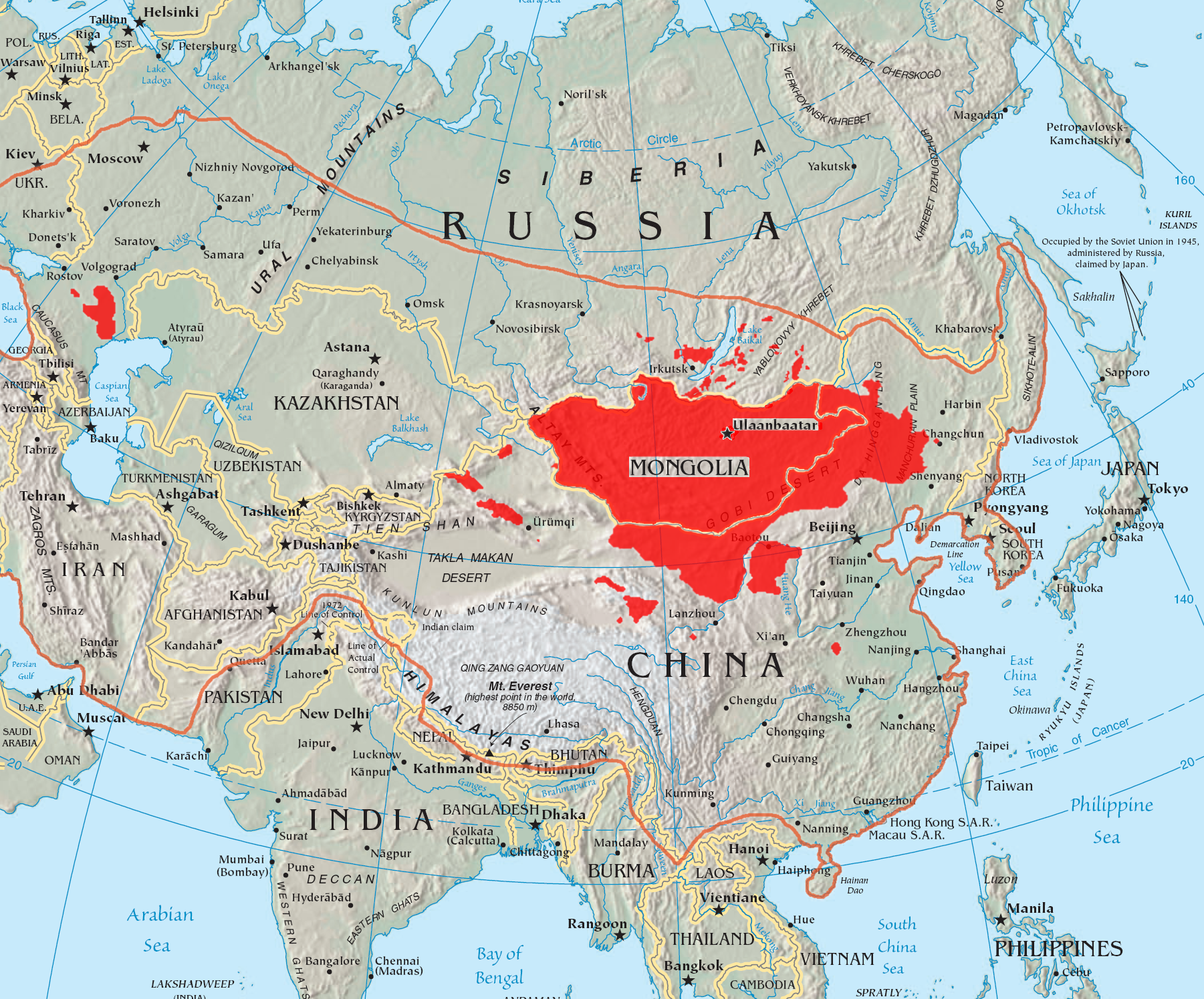
| 描述Mongols-map.png |
English: A map of the places that Mongol peoples live.
The orange line shows the extent of the Mongol Empire in the late 13th century. The red areas are the places dominated by ethnic Mongols. |
| 日期 | |
| 来源 |
|
| 作者 | Quadell |

|
此linguistic map图片可使用矢量图形重新创建为SVG文件。这具有很多好处;更多信息请参见共享资源:待清理媒体。如果存在此图片的SVG格式,请将其上传,然后将此模板替换为
{{vector version available|新图片名称}}。
建议您将SVG命名为“Mongols-map.svg”,这样在使用Vector version available(或Vva)模板时就不需要填写新图片名称参数。 |
许可协议
我,本作品著作权人,特此采用以下许可协议发表本作品:

|
已授权您依据自由软件基金会发行的无固定段落及封面封底文字(Invariant Sections, Front-Cover Texts, and Back-Cover Texts)的GNU自由文件许可协议1.2版或任意后续版本的条款,复制、传播和/或修改本文件。该协议的副本请见“GNU Free Documentation License”。http://www.gnu.org/copyleft/fdl.htmlGFDLGNU Free Documentation Licensetruetrue |
| 本文件采用知识共享署名-相同方式共享 3.0 未本地化版本许可协议授权。 | ||
| ||
| 本许可协议标签作为GFDL许可协议更新的组成部分被添加至本文件。http://creativecommons.org/licenses/by-sa/3.0/CC BY-SA 3.0Creative Commons Attribution-Share Alike 3.0truetrue |
本文件采用知识共享署名-相同方式共享 2.0 通用许可协议授权。
- 您可以自由地:
- 共享 – 复制、发行并传播本作品
- 修改 – 改编作品
- 惟须遵守下列条件:
- 署名 – 您必须对作品进行署名,提供授权条款的链接,并说明是否对原始内容进行了更改。您可以用任何合理的方式来署名,但不得以任何方式表明许可人认可您或您的使用。
- 相同方式共享 – 如果您再混合、转换或者基于本作品进行创作,您必须以与原先许可协议相同或相兼容的许可协议分发您贡献的作品。
您可以选择您需要的许可协议。
说明
添加一行文字以描述该文件所表现的内容
Mapa przedstawia rozmieszczenie ludności mongolskiej
此文件中描述的项目
描繪內容
16 7 2005
image/png
文件历史
点击某个日期/时间查看对应时刻的文件。
| 日期/时间 | 缩略图 | 大小 | 用户 | 备注 | |
|---|---|---|---|---|---|
| 当前 | 2023年5月29日 (一) 14:37 | | 1,801 × 1,495(2.79 MB) | Artanisen | High resolution map with the same borders and areas as version 17:34, 16 July 2005 (UTC) |
| 2021年4月10日 (六) 20:13 |  | 728 × 525(279 KB) | Fæ | Reverted to version as of 17:34, 16 July 2005 (UTC) Untrusted work of sockpuppets | |
| 2019年1月17日 (四) 03:35 |  | 728 × 525(295 KB) | Anchuhu | mongol | |
| 2017年6月22日 (四) 10:56 |  | 728 × 525(630 KB) | 일성강 | Reverted to version as of 12:47, 1 June 2017 (UTC) | |
| 2017年6月17日 (六) 08:54 |  | 728 × 525(279 KB) | Calthinus | Reverted to version as of 17:34, 16 July 2005 (UTC) | |
| 2017年6月1日 (四) 12:47 |  | 728 × 525(630 KB) | 일성강 | fixed | |
| 2005年7月16日 (六) 17:34 |  | 728 × 525(279 KB) | Hottentot~commonswiki | This is a map of the places that Mongol peoples live. The information is based off of w:en:Image:Mongolsethnic.jpg, and the map I started with is w:en:Image:Asia-map.png. The orange line shows the extent of the Mongol Empire in the late 13th c | |
| 2005年7月16日 (六) 13:14 |  | 728 × 525(297 KB) | Quadell | This is a map of the places that Mongol peoples live. The information is based off of [:w:en:Image:Mongolsethnic.jpg]], and the map I started with is w:en:Image:Asia-map.png. The orange line shows the extent of the Mongol Empire in the late 13th ce |
文件用途
全域文件用途
以下其他wiki使用此文件:
- af.wikipedia.org上的用途
- an.wikipedia.org上的用途
- ar.wikipedia.org上的用途
- arz.wikipedia.org上的用途
- ast.wikipedia.org上的用途
- azb.wikipedia.org上的用途
- ba.wikipedia.org上的用途
- be-tarask.wikipedia.org上的用途
- be.wikipedia.org上的用途
- bg.wiktionary.org上的用途
- bh.wikipedia.org上的用途
- br.wikipedia.org上的用途
- bs.wikipedia.org上的用途
- ca.wikipedia.org上的用途
- ckb.wikipedia.org上的用途
- cs.wikipedia.org上的用途
- cv.wikipedia.org上的用途
- da.wikipedia.org上的用途
- diq.wikipedia.org上的用途
- dsb.wikipedia.org上的用途
- el.wikipedia.org上的用途
- en.wikipedia.org上的用途
查看本文件的更多全域用途。
元数据
此文件中包含有扩展的信息。这些信息可能是由数码相机或扫描仪在创建或数字化过程中所添加。
如果此文件的源文件已经被修改,一些信息在修改后的文件中将不能完全反映出来。
| 水平分辨率 | 71 dpi |
|---|---|
| 垂直分辨率 | 71 dpi |
| 色彩空间 | 无标定 |
| 图像宽度 | 1,801 px |
| 图像高度 | 1,495 px |
| 使用软件 | Adobe Photoshop CC 2015 (Windows) |
| 数字化日期时间 | 2023年5月29日 (一) 17:17 |
| 文件修改日期时间 | 2023年5月29日 (一) 18:33 |
| 原始数据最后修改日期 | 2023年5月29日 (一) 18:33 |
| 原始文件唯一ID | xmp.did:ce56d03b-8dad-eb4e-a393-1b2d7714b062 |