File:WW2-Holocaust-Poland.PNG
維基百科,自由的 encyclopedia
本预览的尺寸:557 × 600像素。 其他分辨率:223 × 240像素 | 446 × 480像素 | 713 × 768像素 | 951 × 1,024像素 | 2,007 × 2,161像素。
原始文件 (2,007 × 2,161像素,文件大小:1.34 MB,MIME类型:image/png)

|
此map图片可使用矢量图形重新创建为SVG文件。这具有很多好处;更多信息请参见共享资源:待清理媒体。如果存在此图片的SVG格式,请将其上传,然后将此模板替换为
{{vector version available|新图片名称}}。
建议您将SVG命名为“WW2-Holocaust-Poland.svg”,这样在使用Vector version available(或Vva)模板时就不需要填写新图片名称参数。 |
摘要
| 描述WW2-Holocaust-Poland.PNG |
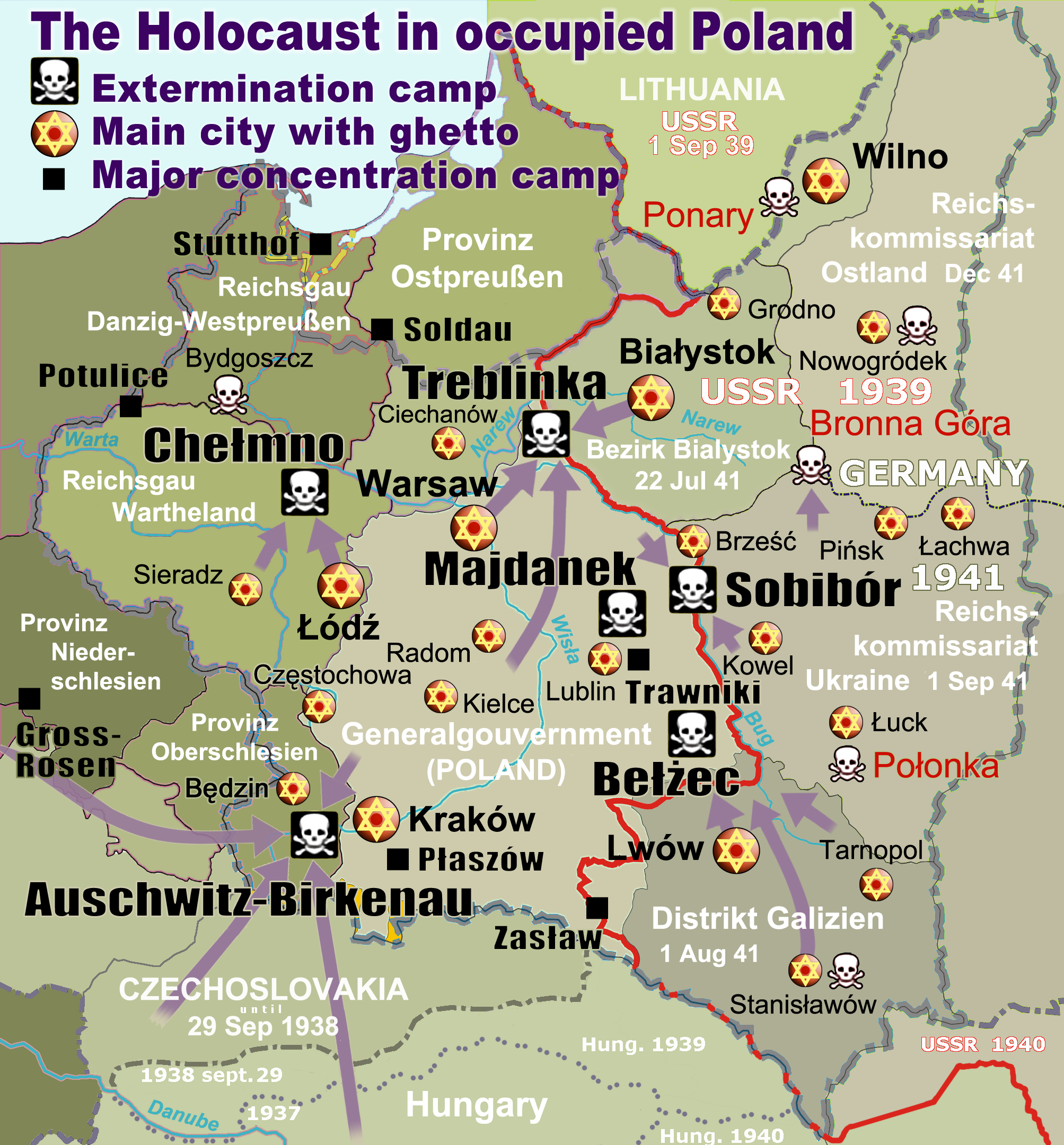
English: Map of the Holocaust in occupied Poland during World War II. The outline shows the borders of the Second Polish Republic at the time of the Nazi-German-and-Soviet invasion of Poland in 1939 with demarcation line between the two invading armies marked in red. Internal boundaries show the administrative divisions of occupied territories imposed by Nazi Germany when the Final Solution was set in motion during and after Operation Barbarossa of 1941. This map shows all Nazi German extermination camps (or death camps), as well as prominent concentration, labour and prison camps, major pre-WW2 Polish cities with the new Jewish ghettos set up by Nazi Germany, major deportation routes, and major massacre sites. Notes: 1. Extermination camps – marked with white skulls in black squares – are six dedicated facilities used for the mass gassings of prisoners, but all camps and ghettos took a toll of many, many lives. 2. Concentration camps – marked with black squares – feature only the most notorious forced-labor camps, prison camps & transit camps. 3. Sites of mass shootings into remote ravines – marked with white skulls – include Bronna Góra, Ponary and others. They were utilized during the 'Holocaust by bullets'. 4. Destruction ghettos – marked with Yellow stars in red circles – existed in most Polish cities. Only a selection is shown. 5. Major deportation routes travelled by the Holocaust trains are marked with RosyBrown arrows. 6. Most camps & ghettos which are not well known have been excluded for clarity. 7. District borders are at the height of Axis domination (1942). 8. Regions have German designations (e.g. "Ostland"), with the country name denoted in uppercase letters, e.g. LITHUANIA, CZECHOSLOVAKIA, or in parenthesis below the German occupational designation, e.g. (POLAND). |
| 日期 | |
| 来源 |
自己的作品. Composite map derived from a variety of readily available sources which may or may not include:
|
| 作者 |
|
| 授权 (二次使用本文件) |
PD, see below. The map is completely unrestricted for any Wikipedia/Wikimedia project. |
| 其他版本 |
[编辑]
|


.png)


.png)


许可协议
For all derivative works of maps uploaded earlier see below.
Poeticbent (en),本作品著作权人,特此采用以下许可协议发表本作品:
| Public domainPublic domainfalsefalse |
| 我,本作品著作权人,释出本作品至公有领域。这适用于全世界。 在一些国家这可能不合法;如果是这样的话,那么: 我无条件地授予任何人以任何目的使用本作品的权利,除非这些条件是法律规定所必需的。 |
- File uploaded previously
Dennis Nilsson,本作品著作权人,特此采用以下许可协议发表本作品:
本文件采用知识共享署名 3.0 未本地化版本许可协议授权。
署名: Dennis Nilsson
- 您可以自由地:
- 共享 – 复制、发行并传播本作品
- 修改 – 改编作品
- 惟须遵守下列条件:
- 署名 – 您必须对作品进行署名,提供授权条款的链接,并说明是否对原始内容进行了更改。您可以用任何合理的方式来署名,但不得以任何方式表明许可人认可您或您的使用。
Derivative work: Piotr Konieczny aka Prokonsul Piotrus Talk 此文件衍生的作品:
Derivative work: User:Poeticbent (Talk) 此文件衍生的作品:
- Uploaded previously
| 这是一张修改过的图片,这意味着它已在原版本的基础上通过软件进行了编辑,改动内容:Smaller version: occupied Poland only (pre-WWII borders)。其原始版本为:WW2-Holocaust-Europe.png。
|
我,本作品著作权人,特此采用以下许可协议发表本作品:
本文件采用知识共享署名 3.0 未本地化版本许可协议授权。
- 您可以自由地:
- 共享 – 复制、发行并传播本作品
- 修改 – 改编作品
- 惟须遵守下列条件:
- 署名 – 您必须对作品进行署名,提供授权条款的链接,并说明是否对原始内容进行了更改。您可以用任何合理的方式来署名,但不得以任何方式表明许可人认可您或您的使用。
原始上传日志
For derivative works of the first uploaded file created by User:Dna-webmaster see the following:
- File:WW2-Holocaust-Europe.png licensed with Cc-by-3.0
Uploaded with derivativeFX
说明
添加一行文字以描述该文件所表现的内容
Holocaust in occupied Poland
Το ολοκαύτωμα στην κατεχόμενη Πολωνία
Holocaust in das besetzte Polen
著作权持有者释出至公有领域 简体中文(已转写)
27 6 2013
image/png
文件历史
点击某个日期/时间查看对应时刻的文件。
| 日期/时间 | 缩略图 | 大小 | 用户 | 备注 | |
|---|---|---|---|---|---|
| 当前 | 2020年3月10日 (二) 15:46 | | 2,007 × 2,161(1.34 MB) | Claude Zygiel | Cosmetics |
| 2018年3月28日 (三) 20:33 |  | 2,007 × 2,161(1.48 MB) | Poeticbent | not an improvement: img looks muddy but I have original Photoshop layers, and can adjust them individually; comment on specifics in talk please | |
| 2018年3月27日 (二) 17:48 |  | 2,007 × 2,161(1.49 MB) | Hohum | Too much information competing for attention in a very busy image. Toned down region name brightness, desaturated slightly. | |
| 2017年7月10日 (一) 05:38 |  | 2,007 × 2,161(1.48 MB) | Poeticbent | vital updates following a discussion → prominent ghettos, legend | |
| 2015年7月25日 (六) 19:43 |  | 2,007 × 2,161(1.46 MB) | Poeticbent | name of settlement: Górka Połonka, source Wolyn.ovh.org | |
| 2014年12月2日 (二) 18:27 |  | 2,007 × 2,161(1.46 MB) | Poeticbent | added one missing marker | |
| 2014年5月7日 (三) 19:17 |  | 2,007 × 2,161(1.45 MB) | Poeticbent | location of Bronna Góra | |
| 2014年4月4日 (五) 17:34 |  | 2,007 × 2,161(1.44 MB) | Poeticbent | Lachwa Ghetto location | |
| 2013年6月27日 (四) 21:31 |  | 2,007 × 2,161(1.42 MB) | Poeticbent | major expansion with similar color-scheme | |
| 2011年6月28日 (二) 03:09 |  | 364 × 339(123 KB) | LMK3 | changed the color of the Soviet Curzon line to indicate the two different occupation zones before Operation Barbarossa, refined the location of Warsaw |
文件用途
以下25个页面使用本文件:
全域文件用途
以下其他wiki使用此文件:
- ar.wikipedia.org上的用途
- azb.wikipedia.org上的用途
- az.wikipedia.org上的用途
- bg.wikipedia.org上的用途
- bn.wikipedia.org上的用途
- br.wikipedia.org上的用途
- ca.wikipedia.org上的用途
- cs.wikipedia.org上的用途
- cs.wikibooks.org上的用途
- da.wikipedia.org上的用途
- de.wikipedia.org上的用途
- el.wikipedia.org上的用途
- Γκέτο της Τσενστοχόβα
- Γκέτο του Μπέντζιν
- Γκέτο του Μίζοτς
- Μπρόνα Γκούρα
- Γκέτο της Κρακοβίας
- Γκέτο του Μπζέσκο
- Στρατόπεδο συγκέντρωσης Τραβνίκι
- Στρατόπεδο συγκέντρωσης Ποτουλίτσε
- Γκέτο του Σοσνόβιετς
- Γκέτο του Ντροχόμπιτς
- Γκέτο του Ταρνόπολ
- Ιστορία των Εβραίων στην Πολωνία
- Γκέτο του Σιέντλτσε
- Γκέτο της Γουόμζα
- Γκέτο του Γκορλίτσε
- Γκέτο του Μπιαουίστοκ
- Γκέτο του Μπζεστς
- Γκέτο του Ράντομ
- Γκέτο του Νόβι Σοντς
查看本文件的更多全域用途。
元数据
此文件中包含有扩展的信息。这些信息可能是由数码相机或扫描仪在创建或数字化过程中所添加。
如果此文件的源文件已经被修改,一些信息在修改后的文件中将不能完全反映出来。
| 水平分辨率 | 28.35 dpc |
|---|---|
| 垂直分辨率 | 28.35 dpc |