Top Qs
Timeline
Chat
Perspective
Williams County, Ohio
County in Ohio, United States From Wikipedia, the free encyclopedia
Remove ads
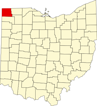
Williams County is a county located in the U.S. state of Ohio. As of the 2020 census, the population was 37,102,[1] and was estimated to be 36,554 in 2024.[2] The county seat and the largest city is Bryan.[3]
Remove ads
History
The county was created on April 1, 1820 and later organized on February 2, 1824.[4] It is named for David Williams, one of the captors of John André in the American Revolutionary War.[5]
Geography
According to the United States Census Bureau, the county has a total area of 423.092 square miles (1,095.80 km2), of which 420.660 square miles (1,089.50 km2) is land and 2.432 square miles (6.30 km2) (0.57%) is water.[6] It is the 53rd largest county in Ohio by total area.[7]
Adjacent counties
- Hillsdale County, Michigan (north)
- Fulton County (east)
- Henry County (southeast)
- Defiance County (south)
- DeKalb County, Indiana (southwest)
- Steuben County, Indiana (northwest)
Remove ads
Demographics
Summarize
Perspective
As of the fourth quarter of 2024, the median home value in Williams County was $150,917.[13]
As of the 2023 American Community Survey, there are 15,455 estimated households in Williams County with an average of 2.32 persons per household. The county has a median household income of $61,834. Approximately 11.1% of the county's population lives at or below the poverty line. Williams County has an estimated 61.6% employment rate, with 14.2% of the population holding a bachelor's degree or higher and 91.4% holding a high school diploma.[2]
The top five reported ancestries (people were allowed to report up to two ancestries, thus the figures will generally add to more than 100%) were English (96.3%), Spanish (2.4%), Indo-European (0.7%), Asian and Pacific Islander (0.6%), and Other (0.1%).
The median age in the county was 41.8 years.
Williams County, Ohio – racial and ethnic composition
Note: the US Census treats Hispanic/Latino as an ethnic category. This table excludes Latinos from the racial categories and assigns them to a separate category. Hispanics/Latinos may be of any race.
2024 estimate
As of the 2024 estimate, there were 36,554 people and 15,455 households residing in the county. There were 16,624 housing units at an average density of 39.52 per square mile (15.3/km2). The racial makeup of the county was 96.1% White (91.1% NH White), 1.4% African American, 0.4% Native American, 0.6% Asian, 0.0% Pacific Islander, _% from some other races and 1.4% from two or more races. Hispanic or Latino people of any race were 5.6% of the population.[19]
2020 census
As of the 2020 census, there were 37,102 people, 15,262 households, and 9,858 families residing in the county.[20] The population density was 88.2 inhabitants per square mile (34.1/km2). There were 16,561 housing units at an average density of 39.37 per square mile (15.2/km2). The racial makeup of the county was 92.08% White, 0.90% African American, 0.23% Native American, 0.54% Asian, 0.02% Pacific Islander, 1.77% from some other races and 4.46% from two or more races. Hispanic or Latino people of any race were 5.02% of the population.[21]
2010 census
As of the 2010 census, there were 37,642 people, 15,075 households, and 10,260 families residing in the county. The population density was 89.4 inhabitants per square mile (34.5/km2). There were 16,668 housing units at an average density of 39.59 per square mile (15.3/km2). The racial makeup of the county was 95.95% White, 0.96% African American, 0.23% Native American, 0.57% Asian, 0.02% Pacific Islander, 1.08% from some other races and 1.19% from two or more races. Hispanic or Latino people of any race were 3.69% of the population.
In terms of ancestry, 46.1% were German, 12.0% were Irish, 10.7% were English, and 7.8% were American.
There were 15,075 households, 31.0% had children under the age of 18 living with them, 53.0% were married couples living together, 9.9% had a female householder with no husband present, 31.9% were non-families, and 27.0% of all households were made up of individuals. The average household size was 2.43 and the average family size was 2.93. The median age was 40.7 years.
The median income for a household in the county was $44,538 and the median income for a family was $52,975. Males had a median income of $40,658 versus $29,064 for females. The per capita income for the county was $21,381. About 9.1% of families and 11.8% of the population were below the poverty line, including 17.6% of those under age 18 and 8.6% of those age 65 or over.
Remove ads
Politics
Summarize
Perspective
Williams County is a Republican stronghold county in presidential elections. The last Democrat to win the county was Lyndon B. Johnson in 1964.
Remove ads
Government
Williams County has three county commissioners who oversee the various county departments. Current commissioners are: Brian Davis, Lewis Hilkert, and Terry Rummel.[23]
Communities


City
- Bryan (county seat)
Villages
Townships
Census-designated places
Unincorporated communities
Remove ads
See also
References
External links
Wikiwand - on
Seamless Wikipedia browsing. On steroids.
Remove ads


