Top Qs
Timeline
Chat
Perspective
List of U.S. states and territories by elevation
Elevation extremes of United States by state, district, and territory From Wikipedia, the free encyclopedia

Remove ads
This list includes the topographic elevations of each of the 50 U.S. states, the District of Columbia, and the U.S. territories.[1]

The elevation of a geographic area may be stated in several ways. These include:
- The maximum elevation of the area (high point);[a]
- The minimum elevation of the area (low point);[b]
- The arithmetic mean elevation of the area (statistical mean elevation);[c]
- The median elevation of the area (statistical 50% elevation);[d] and
- The elevation range of the area.[e]
All topographic elevations are adjusted to the North American Vertical Datum of 1988 (NAVD 88). All geographic coordinates are adjusted to the World Geodetic System of 1984 (WGS 84). The mean elevation for each state, the District of Columbia, and Puerto Rico are accurate to the nearest 100 feet (30 m). Mean elevation data is not available for the other U.S. territories.
Remove ads
Cultural significance
Those who try to summit the highest point in each U.S. state and territory are known as highpointers.[2]
Elevations
Summarize
Perspective
Minor outlying islands
The highest points in the U.S. minor outlying islands, mostly unnamed:
- Baker Island high point – 26 feet (8 m)[92]
- Howland Island high point – 10 feet (3 m)[92]
- Jarvis Island high point – 23 feet (7 m)[92]
- Johnston Atoll, Sand Island high point – 33 feet (10 m)[92]
- Kingman Reef high point – less than 7 feet (2 m)[92]
- Midway Atoll, Sand Island high point – 50 feet (15 m)[92] – The highest point of the U.S. minor outlying islands in the Pacific Ocean.
- Navassa Island high point – 280 feet (85 m)[91] – The highest point of all the U.S. minor outlying islands.
- Palmyra Atoll high point – 10 feet (3 m)[92]
- Wake Island high point – 26 feet (8 m)[93]
Remove ads
Highpoint gallery (in order of elevation)

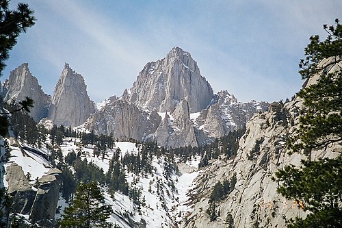 2. Mount Whitney in California
 3. Mount Elbert in Colorado
 4. Mount Rainier in Washington
 5. Gannett Peak in Wyoming
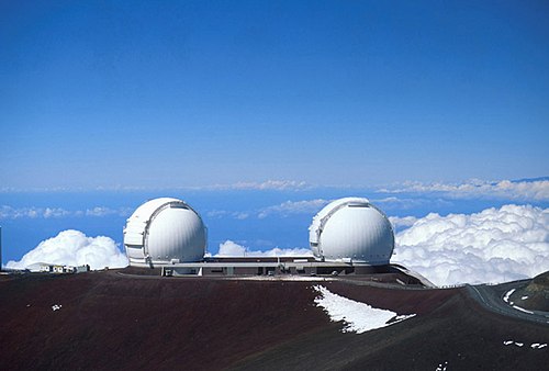
 7. Kings Peak in Utah
 8. Wheeler Peak in New Mexico
 9. Boundary Peak in Nevada
 10. Granite Peak in Montana
 11. Borah Peak in Idaho
 12. Humphreys Peak in Arizona
 13. Mount Hood in Oregon
 14. Guadalupe Peak in Texas
 15. Black Elk Peak in South Dakota (formerly Harney Peak)
 16. Mount Mitchell in North Carolina
 18. Mount Washington in New Hampshire
 19. Mount Rogers in Virginia
 20. Panorama Point in Nebraska
 21. Mount Marcy in New York
 22. Mount Katahdin in Maine
 23. Black Mesa in Oklahoma
 24. Spruce Knob in West Virginia (background mountain)
 25. Brasstown Bald in Georgia (background mountain)
 26. Mount Mansfield in Vermont
 27. Cerro de Punta in Puerto Rico
 28. Black Mountain in Kentucky
 29. Mount Sunflower in Kansas
 30. Sassafras Mountain in South Carolina
 31. White Butte in North Dakota
 32. Mount Greylock in Massachusetts
 33. Hoye-Crest in Maryland
 34. Mount Davis in Pennsylvania (background mountain)
 35. Mount Agrihan in the Northern Mariana Islands
 36. Lata Mountain in American Samoa
 37. Mount Magazine in Arkansas
 38. Cheaha Mountain in Alabama
 39. Southern Slope of Mount Frissell in Connecticut
 40. Eagle Mountain in Minnesota
 41. Mount Arvon in Michigan
 42. Timms Hill in Wisconsin
 43. High Point in New Jersey
 44. Taum Sauk Mountain in Missouri
 45. Hawkeye Point in Iowa
 46. Crown Mountain in the US Virgin Islands
 47. Campbell Hill in Ohio
 48. Mount Lamlam in Guam
 49. Hoosier Hill in Indiana
 50. Charles Mound in Illinois
 51. Jerimoth Hill in Rhode Island
 52. Woodall Mountain in Mississippi
 53. Driskill Mountain in Louisiana
 54. Ebright Azimuth in Delaware
 55. Point Reno in the District of Columbia
 56. Britton Hill in Florida
 57. The highest point of Navassa Island is the highest point of all the US Minor Outlying Islands.


.jpg)
_summit.JPG)


.jpg)


Remove ads
Lowpoint gallery
 The Badwater Basin in Death Valley is the lowest point in California, the United States, and all of North America.
 The lowpoints of Alabama, Alaska, American Samoa, Connecticut, Delaware, Florida, Georgia, Guam, Hawaii, Maine, Maryland, Massachusetts, Mississippi, New Hampshire, New Jersey, New York, North Carolina, the Northern Mariana Islands, Oregon, Pennsylvania, Puerto Rico, Rhode Island, South Carolina, Texas, the US Virgin Islands, Virginia, Washington, and the US Minor Outlying Islands are all at sea level.
 The Arikaree River at the Colorado-Kansas border is the lowest point in Colorado, and the highest state lowpoint in the United States.


Remove ads
See also
Remove ads
Notes
- A high point may be (1.) a topographic summit, or (2.) a point on a border.
- A low point may be (1.) the border crossing of a gulch, stream, or river; or (2.) the shore of a reservoir, lake, or ocean; or (3.) the bottom of an endorheic basin. The elevation of a stream, river, reservoir, or lake will vary seasonally. The bottom of an endorheic basin may fill with water.
- Coordinates are adjusted to the World Geodetic System of 1984 (WGS 84).
- Alaska has the highest point in North America and the greatest elevation range of any U.S. state.
- The summit of Denali is the highest point in the United States and all of North America. Federally designated as Mount McKinley, Denali is both the third most topographically prominent summit and the third most topographically isolated summit on Earth. Denali is the highest point in the entire Arctic Ocean Basin.
- Mount Magazine is the highest summit of the Ozarks.
- California has the lowest point in North America. California also has the highest point and greatest elevation range of any U.S. state except Alaska.
- Mount Whitney is the highest summit of the Sierra Nevada. Mount Whitney is the highest point of both the San Joaquin Basin and the Great Basin.
- The Badwater Basin, an endorheic basin in Death Valley, is the lowest point in the United States and all of North America. The Salton Sea, an endorheic basin with the lowest water level in North America, is currently near the −239.6-foot (−73.0 m) level.[14]
- Colorado has the highest mean elevation and the highest low point of any U.S. state.
- Mount Elbert is the highest summit of the Rocky Mountains of the United States and Canada. Mount Elbert is the highest point in the Mississippi River Basin.
- The point where the Arikaree River flows out of Colorado and into Kansas is the highest low point of any U.S. state, higher than the high points of 18 states and the District of Columbia.
- Connecticut is the only U.S. state with a high point that is not a topographic summit, although several other high points have a topographic prominence of less than 50 feet (15 m). The highest summit in Connecticut is Bear Mountain, approximately 1.45 miles (2.33 km) south-southeast; its exact elevation is disputed, but it is at least 60 feet (18 m) lower than the highest point on Mount Frissell in Connecticut.[18]
- Delaware has the lowest mean elevation of any U.S. state or the District of Columbia.
- Florida has the lowest high point and the smallest elevation range of any U.S. state or the District of Columbia.
- Britton Hill is the lowest high point of any U.S. state or the District of Columbia.
- Although only 1,332 feet (406 m) above sea level, the summit of Mount Lamlam is 195 miles (314 km) northeast and 37,160 feet (11,330 m) above the Challenger Deep.
- Mauna Kea is the highest summit of the island of Hawaiʻi and the entire North Pacific Ocean. Hawaiʻi is second only to New Guinea as the tallest island on Earth. Mauna Kea is the tallest mountain on Earth if measured from its base at −19,684 feet (−6,000 m) below the surface of the Pacific Ocean to its summit at 13,796 feet (4,205 m) for a total rise of 33,480 feet (10,205 m).[29] Neighboring Mauna Loa is the most voluminous mountain on Earth.[30]
- Charles Mound is approximately 1,300 feet (400 m) south of the Wisconsin border.
- Mount Sunflower is approximately 2,630 feet (800 m) east of the Colorado border.
- Louisiana is the only U.S. region with land below sea level outside of California.
- Mount Katahdin is the highest summit of the Longfellow Mountains.
- Mount Greylock is the highest summit of the Berkshires.
- The summit of Mount Arvon is the highest point on the Upper Peninsula of Michigan.
- Taum Sauk Mountain is the highest summit of the St. Francois Mountains.
- Granite Peak is the highest summit of the Beartooth Mountains.
- Panorama Point is approximately 2,210 feet (670 m) north of the Colorado border.
- The summit of Boundary Peak is approximately 1,440 feet (440 m) northeast of the California border.
- Mount Washington is the highest summit of the White Mountains. The summit of Mount Washington is the highest point on the northeastern Northern American continent.
- Wheeler Peak is the highest summit of the Taos Mountains.
- Mount Marcy is the highest summit of the Adirondack Mountains.
- Mount Mitchell is the highest summit of the Appalachian Mountains. The summit of Mount Mitchell is the highest point on the eastern Northern American continent.
- The summit of Mount Agrihan is the highest point in the Northern Mariana Islands and all of Micronesia.[65]
- Mount Hood is the highest summit of the Oregon Cascades.
- Puerto Rico has the highest point and greatest elevation range of any of the U.S. territories.
- Cerro de Punta is the highest point in any of the U.S. territories.
- Black Elk Peak is the highest summit of the Black Hills.
- Kuwohi is the highest summit of the Great Smoky Mountains.
- Guadalupe Peak is the highest summit of the Guadalupe Mountains.
- Kings Peak is the highest summit of the Uinta Mountains and the Western Rocky Mountains.
- Mount Mansfield is the highest summit of the Green Mountains.
- Mount Rainier is the highest summit of the Cascade Range of the United States and Canada.
- Gannett Peak is the highest summit of the Wind River Range and the Central Rocky Mountains. Gannett Peak is the highest point in the Green River Basin.
Remove ads
References
External links
Wikiwand - on
Seamless Wikipedia browsing. On steroids.
Remove ads