Top Qs
Timeline
Chat
Perspective
List of highest U.S. county high points
List of the highest county high points of the United States From Wikipedia, the free encyclopedia
Remove ads
The following table lists the 60 highest United States county or county-equivalent[a] high points.[b] The highest U.S. county high point is the summit of Denali in the Denali Borough of Alaska, the highest summit of the United States and all of North America. Of these 60 highest county high points, 32 are located in Colorado, seven in California, six each in Alaska and Wyoming, three in New Mexico, two each in Utah and Nevada, and one each in Washington and Hawaiʻi. Use the OpenStreetMap link below to view the location of these county high points.

Remove ads
Highest U.S. county high points
Summarize
Perspective
Remove ads
Gallery
 1. Denali in Denali Borough, Alaska
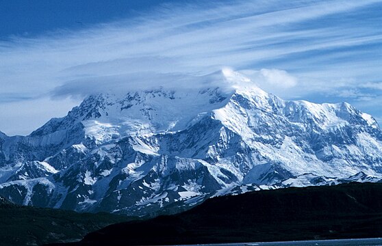
 3. Mount Bona in the Copper River Census Area, Alaska


_-_2006-07-16.jpg)


Remove ads
See also
Notes
- Forty-eight U.S. states have counties, Louisiana has parishes, and Alaska has boroughs and census areas in the Unorganized Borough. The entire District of Columbia is considered a county-equivalent, as are the 38 independent cities of Virginia, and the independent cities of Baltimore, Maryland, St. Louis, Missouri, and Carson City, Nevada.[1]
- The high point of an area is the point of maximum topographic elevation. The high point may, or may not, be a summit.
- Rank among United States counties and county-equivalents[1] by high point elevation.[b]
- Topographic elevations are adjusted to the North American Vertical Datum of 1988 (NAVD 88).[6]
- The low point of an area is the point of minimum topographic elevation. The low point is often a gulch, stream, river, reservoir, lake, ocean, or endorheic basin.
- The "mean of extremes" elevation is the arithmetic mean of the highest and lowest elevations.
- The elevation range is the arithmetic difference between the highest and lowest elevations.
- Geodetic coordinates are adjusted to the World Geodetic System of 1984 (WGS 84).[7]
- The Denali Borough, Alaska has the greatest elevation range[g] of any U.S. county or county-equivalent[a] at 19,925 feet (6,073 m).
- The summit of Denali is the highest point in the United States and all of North America with an elevation of 20,310 feet (6,190.5 m). Denali is both the third most topographically prominent summit and the third most topographically isolated summit on Earth after Mount Everest and Aconcagua. Denali is the highest point in the Arctic Ocean Basin.
- Mount Saint Elias is the highest summit of the Saint Elias Mountains and the second highest major summit of both Canada and the United States.
- Mount Fairweather is the highest summit of the Fairweather Range.
- Mount Whitney is the highest summit of the Sierra Nevada and the State of California. Mount Whitney is the highest point of both the San Joaquin Basin and the Great Basin.
- Inyo County, California, has the sixth highest U.S. county high point and lowest point of all of North America for a county elevation range of 14,787 feet (4,507 m), the greatest south of Alaska.
- The Badwater Basin, an endorheic basin in Death Valley, is the lowest point in the United States and all of North America with an elevation of −282 feet (−86 m).
- Lake County, Colorado is the highest county in the United States by mean elevation[f] at 11,702 feet (3,567 m).
- Mount Elbert is the highest summit of the Rocky Mountains of the United States and Canada. Mount Elbert is the highest summit of the State of Colorado and the highest point in the Mississippi River Basin.
- The point where the Arkansas River flows out of Lake County and into Chaffee County, Colorado, is the highest county low point in the United States at 8,965 feet (2,733 m) elevation.
- Mount Harvard is the highest summit of the Collegiate Peaks and the easternmost point of its elevation in the United States.
- Mount Rainier is the highest summit of the State of Washington and the highest summit of the Cascade Range of the United States and Canada.
- Blanca Peak is the highest summit of the Sangre de Cristo Range and the easternmost point of its elevation in the United States. Blanca Peak is the highest point in the Rio Grande Basin of the United States and México.
- The Blanca Peak Tripoint is located 140 feet (43 m) north-northeast and 25 feet (7.6 m) below the summit of Blanca Peak. The Tripoint is the junction of Alamosa, Costilla, and Huerfano counties, Colorado. This point gave surveyors a better point to set the intersection of the three counties than the summit itself.
- Uncompahgre Peak is the highest summit of the San Juan Mountains. Uncompahgre Peak is the highest point in the Colorado River Basin of the United States and México.
- Mount Lincoln is the highest summit of the Mosquito Range.
- Castle Peak is the highest summit of the Elk Mountains.
- Grays Peak is the highest summit of the Front Range and the highest point on the Continental Divide in North America.
- Crestone East Peak is located 432 feet (132 m) east-northeast and 34 feet (10.4 m) below the summit of Crestone Peak.
- Longs Peak is the highest summit of the northern Front Range.
- Mount Wilson is the highest summit of the San Miguel Mountains.
- White Mountain Peak is the highest summit of the White Mountains.
- North Palisade is the highest summit of the central Sierra Nevada.
- Mount Shasta is the highest summit of the Cascade Range in California.
- Mount Sneffels is the highest summit of the Sneffels Range.
- Pikes Peak is the highest summit of the southern Front Range and the easternmost point of its elevation in the United States.
- Windom Peak is the highest summit of the Needle Mountains.
- Wilson Peak is located 1.51 miles (2.43 km) north-northeast and 229 feet (70 m) lower than the summit of Mount Wilson.
- Mount of the Holy Cross is the highest summit of the northern Sawatch Range.
- Mount Hayes is the highest summit of the Hayes Range.
- Gannett Peak is the highest summit of the Wind River Range, the Central Rocky Mountains, and the State of Wyoming. Gannett Peak is the highest point in the Green River Basin.
- Mauna Kea is the highest summit of the Island of Hawaiʻi, the State of Hawaiʻi, and the entire North Pacific Ocean. Mauna Kea is the tallest mountain on Earth if measured from its base at −19,684 feet (−6,000 m) below the surface of the Pacific Ocean to its summit at 13,796 feet (4,205 m) for a total of 33,480 feet (10,205 m).
- Grand Teton is the highest summit of the Teton Range. Grand Teton is the highest point in the Columbia River drainage basin of Canada and the United States.
- West Spanish Peak is the higher summit of the two Spanish Peaks. Both Spanish Peaks are the easternmost points of their respective elevation in the United States. The Spanish Peaks were important historic landmarks along the Santa Fe Trail.
- Hagues Peak is the highest summit of the Mummy Range.
- Kings Peak is the highest summit of the Uinta Range, the Western Rocky Mountains, and the State of Utah.
- Gilbert Peak is located 3.7 miles (6.0 km) north-northeast and 86 feet (26 m) lower than the summit of Kings Peak.
- Summit Peak is the highest summit of the southern San Juan Mountains.
- The elevation of Navajo Reservoir varies seasonally.
- Hesperus Mountain is the highest summit of the La Plata Mountains.
- Cloud Peak is the highest summit of the Bighorn Mountains.
- The elevation of Bighorn Lake varies seasonally.
- Wheeler Peak is the highest summit of the Taos Mountains and the State of New Mexico.
- Francs Peak is the highest summit of the Absaroka Range.
- Boundary Peak is the highest summit of the State of Nevada.
- Mount Ritter is the highest summit of the Ritter Range.
- Truchas Peak is the highest summit of the Santa Fe Mountains.
- The Devils Playground is located 2.15 miles (3.46 km) northwest and 1,040 feet (317 m) below the summit of Pikes Peak. The Devils Playground is named for the way lightning sometimes dances around the prominence during lightning storms.
- Wheeler Peak is the highest summit of the Snake Range.
Remove ads
References
External links
Wikiwand - on
Seamless Wikipedia browsing. On steroids.
Remove ads