Top Qs
Timeline
Chat
Perspective
Puerto Rico Highway 510
Highway in Puerto Rico From Wikipedia, the free encyclopedia

Remove ads
Puerto Rico Highway 510 (PR-510) is a tertiary[3] highway in southern Puerto Rico. The road runs north to south in a general south-southwestern direction. The road connects PR-1 in Barrio Capitanejo, Ponce, to PR-14 in the town of Juana Díaz. Portions of the Juana Díaz portion of the road were damaged in September 2017 by Hurricane Maria.[4]
- Puerto Rico Highway 510 by municipality
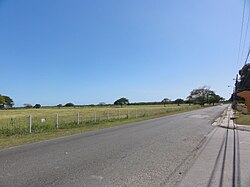 A stretch in Barrio Capitanejo, Ponce, looking south
 Southbound beginning in Barrio Tijeras, Juana Díaz, leaving PR-14
.jpg)

Remove ads
Major intersections
- Kilometer markers represent the distance along PR-149 rather than PR-510.
Remove ads
Related route
Puerto Rico Highway 5510 (PR-5510) is a spur route located in between Ponce and Juana Díaz. It begins at PR-1 in Barrio Capitanejo and ends at its junction with PR-510 in Barrio Sabana Llana.[6]
 Puerto Rico Highway 5510 north in Barrio Capitanejo
 A stretch of PR-5510 in Barrio Capitanejo, looking south
.jpg)
.jpg)
Remove ads
See also
References
External links
Wikiwand - on
Seamless Wikipedia browsing. On steroids.
Remove ads