Top Qs
Timeline
Chat
Perspective
Yanqi Hui Autonomous County
Autonomous county in Xinjiang, China From Wikipedia, the free encyclopedia
Remove ads
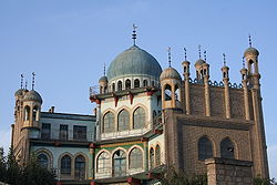
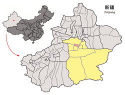
Yanqi Hui Autonomous County (Uyghur: Qarasheher, Karashahr) is an autonomous county in the Xinjiang Uyghur Autonomous Region and is under the administration of the Bayin'gholin Mongol Autonomous Prefecture. It has an area of 2,429 km2 (938 sq mi). According to the 2002 census, it has a population of 120,000. The Shikshin Buddhist Temple Ruins are located in Yanqi County, about 25–30 km (16–19 mi) southwest of the town of Yanqi.
Remove ads
Administrative division
The Yanqi Hui Autonomous County is made up of 4 towns and 4 townships:[2]
Others:
- Wangjiazhuang Pasture (王家庄牧场, ۋاڭجياجۇاڭ چارۋىچىلىق فېرمىسى)
- Suhai Seed Farm (苏海良种场)
Remove ads
Demographics
History
See Karasahr.
Climate
Remove ads
Economy
The county economy is predominantly agricultural with 13,000 hectares used to cultivate red pepper.[6] The county is considered the most important area for red pepper production in China.[6] During the red pepper harvest season beginning in September, the county is home to the remarkable sight of drying peppers sitting in the Gobi Desert "as far as the eye can see".[6]
As of 1885[update], there was about 25,300 acres (167,805 mu) of cultivated land in Kara Shahr.[7]
Remove ads
Notes
- Locals in Xinjiang frequently observe UTC+6 (Xinjiang Time), 2 hours behind Beijing.
References
Wikiwand - on
Seamless Wikipedia browsing. On steroids.
Remove ads


