ファイル:Colonisation_1800.png
ウィキペディア フリーな encyclopedia
元のファイル (1,425 × 625 ピクセル、ファイルサイズ: 42キロバイト、MIME タイプ: image/png)
ウィキメディア・コモンズのファイルページにある説明を、以下に表示します。
|
概要
| 解説Colonisation 1800.png |
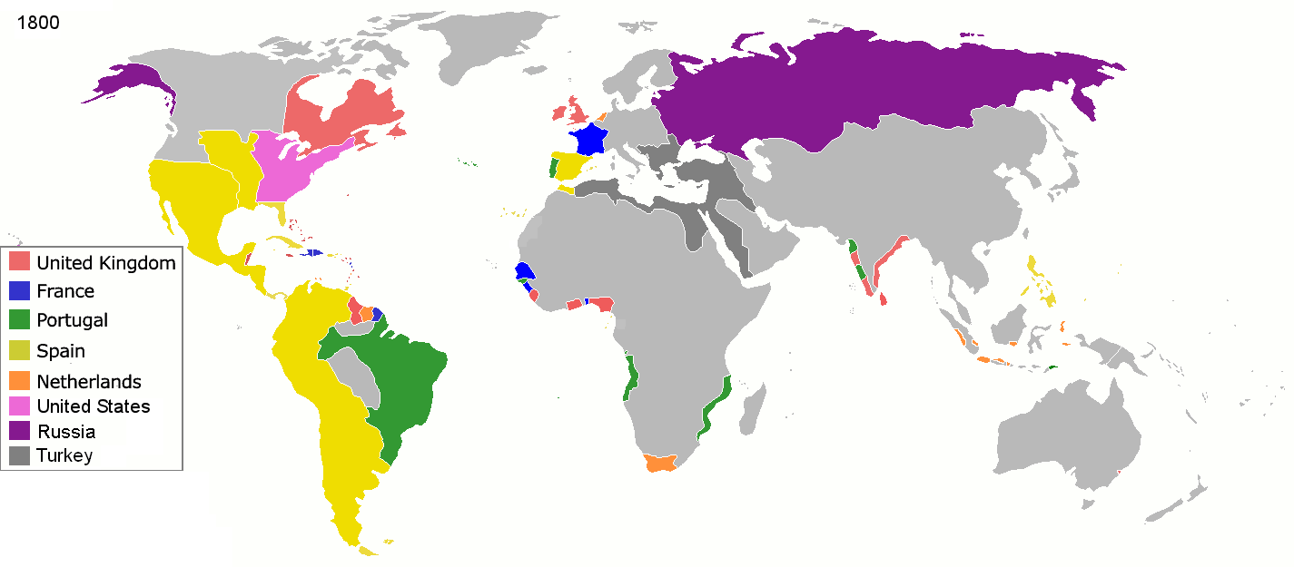
English: Colonial empires in 1800 Français : Empires coloniaux en 1800 Español: Imperios coloniales en 1800 Português: Impérios Coloniais em 1800
|
||||||||||||||||
| 日付 | |||||||||||||||||
| 原典 | 投稿者自身による著作物 | ||||||||||||||||
| 作者 | Jluisrs | ||||||||||||||||
| 許可 (ファイルの再利用) |
|
||||||||||||||||
.jpg)
._LOC_2001620596.jpg)

|
このファイルのベクター画像 (SVG) が利用できます。 使う目的に対し、元画像よりもSVGがより優れている場合、SVG画像を使用して下さい。
File:Colonisation 1800.png → File:Colonial empires in 1800.svg
|
 |
| 注釈 InfoField | この画像には注釈がついています: コモンズで注釈を見る |
The extent of British influence in New Zealand in 1800 was the existence of whaling ships and flax traders. Americans and French were also present in New Zealand waters. Missionary presence had not even been established yet, and gun traders weren't significant until about the time of the Musket Wars. New Zealand not British prior to 1840 annexation. However, under the 1788 amended charter of the New South Wales colony, islands adjacent to that region of Australia within the bounds of 10°37'S and 43°39'S are included under it. This includes all but the Southern half of South Island. Recognizing this might be like recognizing the Treaty of Tordesillas on this map, but there is some basis for most of New Zealand being counted as a British colony on this map. (See: http://en.wikipedia.org/wiki/History_of_new_zealand#British_sovereignty, http://en.wikipedia.org/wiki/43rd_parallel_south) Nanib (talk) 19:08, 8 September 2011 (UTC)
Araucania and Patagonia not colonized or occupied by Europeans. Mapuche groups prevented Southward expansion by Spanish. Chile and Argentina began occupying the region from 1843-1902. http://en.wikipedia.org/wiki/Patagonia#Chilean_and_Argentine_expansion_.281843-1902.29
A Norwegian colony existed at Nuuk from 1728. It became Danish in 1814. http://en.wikipedia.org/wiki/Nuuk
Omanese colonies on East African coast from 1698. It might be good to include this, but if the focus of this map is European-related colonies, then it shouldn't be. http://en.wikipedia.org/wiki/Oman#Oman_and_East_Africa
British may have had further holdings in Bengal. http://en.wikipedia.org/wiki/Company_rule_in_India#Expansion_and_territory
Zeila, in Western Somililand, ruled by Ottomans from 1548. http://en.wikipedia.org/wiki/History_of_Somaliland#Ottoman_Somaliland
Dutch Gold Coast from 1598. It might be too small to show. http://en.wikipedia.org/wiki/Dutch_Gold_Coast
The Spanish East Indies in the Pacific. After its discovery in 1521, all of Micronesia was included in the Captaincy General of the Philippines of Spain, but his claim effectively began in 1885, the year in which the Micronesia partitioned between Spain and Germany.
In 1800 the French occupation lasted (http://en.wikipedia.org/wiki/French_campaign_in_Egypt_and_Syria)
キャプション
このファイルに描写されている項目
題材
ウィキデータ項目がない値
1 3 2008
image/png
1c447d15b6569cd35e35abf1b38379514daaa313
42,860 バイト
625 ピクセル
1,425 ピクセル
ファイルの履歴
過去の版のファイルを表示するには、その版の日時をクリックしてください。
| 日付と時刻 | サムネイル | 寸法 | 利用者 | コメント | |
|---|---|---|---|---|---|
| 現在の版 | 2016年5月1日 (日) 19:28 | | 1,425 × 625 (42キロバイト) | Mega-light | Dominican Republic was a French colonia between 1795 and 1808 through Treaty of Basilea. |
| 2016年5月1日 (日) 19:21 |  | 1,425 × 625 (42キロバイト) | Mega-light | Dominican Republic was a French colonia between 1795 and 1808. | |
| 2014年9月27日 (土) 23:55 |  | 1,425 × 625 (42キロバイト) | Leftcry | minor | |
| 2013年5月16日 (木) 05:48 |  | 1,425 × 625 (40キロバイト) | Kraj35 | British settlement in Australia - Sydney and Parramatta. | |
| 2012年1月16日 (月) 03:30 |  | 1,425 × 625 (52キロバイト) | Quigley | cleaner legend | |
| 2010年4月29日 (木) 14:07 |  | 1,425 × 625 (49キロバイト) | Kieran4 | Border changes | |
| 2010年4月29日 (木) 14:06 |  | 1,425 × 625 (49キロバイト) | Kieran4 | Dutch claims in Indonesia were exaggerated and Cape Colony was too small. | |
| 2010年4月29日 (木) 14:06 |  | 1,425 × 625 (49キロバイト) | Kieran4 | Dutch claims in Indonesia were exaggerated and Cape Colony was too small. | |
| 2009年2月15日 (日) 16:50 |  | 1,425 × 625 (49キロバイト) | EuroHistoryTeacher | lousiana was spanish in 1800, would be french officially in 1803 then sold to USA. no spanish settlement in western sahara, or spanish guinea. USA was not a colonisation power. | |
| 2009年1月21日 (水) 20:38 |  | 1,425 × 625 (49キロバイト) | TashkentFox | {{Information |Description= |Source= |Date= |Author= |Permission= |other_versions= }} |
ファイルの使用状況
グローバルなファイル使用状況
以下に挙げる他のウィキがこの画像を使っています:
- af.wikipedia.org での使用状況
- ast.wikipedia.org での使用状況
- av.wikipedia.org での使用状況
- az.wikipedia.org での使用状況
- ba.wikipedia.org での使用状況
- be.wikipedia.org での使用状況
- ca.wikipedia.org での使用状況
- ce.wikipedia.org での使用状況
- cs.wikipedia.org での使用状況
- da.wikipedia.org での使用状況
- en.wikipedia.org での使用状況
- eo.wikipedia.org での使用状況
- es.wikipedia.org での使用状況
- eu.wikipedia.org での使用状況
- fi.wikipedia.org での使用状況
- fr.wikipedia.org での使用状況
- gl.wikipedia.org での使用状況
- ha.wikipedia.org での使用状況
- he.wikipedia.org での使用状況
- hy.wikipedia.org での使用状況
- id.wikipedia.org での使用状況
- io.wikipedia.org での使用状況
- it.wikipedia.org での使用状況
- ka.wikipedia.org での使用状況
- meta.wikimedia.org での使用状況
- ml.wikipedia.org での使用状況
このファイルのグローバル使用状況を表示する。
メタデータ
このファイルには、追加情報があります (おそらく、作成やデジタル化する際に使用したデジタルカメラやスキャナーが追加したものです)。
このファイルが元の状態から変更されている場合、修正されたファイルを完全に反映していない項目がある場合があります。
| 水平方向の解像度 | 37.8dpc |
|---|---|
| 垂直方向の解像度 | 37.8dpc |