Vaizdas:Eastern_Front_As_of_1917.jpg
From Wikipedia, the free encyclopedia
Didesnės raiškos iliustracija (628 × 951 taškų, rinkmenos dydis: 381 KiB, MIME tipas: image/jpeg)
| Ši byla yra iš bendros Wikimedia Commons nemokamų resursų duomenų bazės, palaikomos Wikimedia Foundation organizacijos. Norėdami sužinoti licencijavimo smulkmenas, žiūrėkite paveikslėlio aprašymą |  |
Į paveikslėlio aprašymą |
Aprašymas
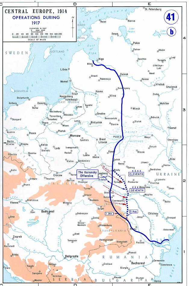
Map of the Eastern Front as of 1917.
From the History Department of the US Military Academy West Point - http://www.dean.usma.edu/history/web03/atlases/great%20war/great%20war%20index.htm archive copy at the Wayback Machine
Licencija
| Public domainPublic domainfalsefalse |
This work is in the public domain in the United States because it is a work prepared by an officer or employee of the United States Government as part of that person’s official duties under the terms of Title 17, Chapter 1, Section 105 of the US Code.
Note: This only applies to original works of the Federal Government and not to the work of any individual U.S. state, territory, commonwealth, county, municipality, or any other subdivision. This template also does not apply to postage stamp designs published by the United States Postal Service since 1978. (See § 313.6(C)(1) of Compendium of U.S. Copyright Office Practices). It also does not apply to certain US coins; see The US Mint Terms of Use.
|
 | |
| This file has been identified as being free of known restrictions under copyright law, including all related and neighboring rights. | ||
https://creativecommons.org/publicdomain/mark/1.0/PDMCreative Commons Public Domain Mark 1.0falsefalse
Rinkmenos istorija
Paspauskite ant datos/laiko, kad pamatytumėte rinkmeną tokią, kokia ji buvo tuo metu.
| Data/Laikas | Miniatiūra | Matmenys | Naudotojas | Paaiškinimas | |
|---|---|---|---|---|---|
| dabartinis | 13:27, 19 birželio 2006 | | 628 × 951 (381 KiB) | Yellowmellow45~commonswiki | Map of the final Allied offensives on the [http://en.wikipedia.org/wiki/Eastern_Front_%28World_War_I%29|Eastern Front] as of 1917. From the History Department of the US Military Academy West Point - http://www.dean.usma.edu/history/web03/atlases/great%20 |
Paveikslėlio naudojimas
Paveikslėlis yra naudojamas šiuose puslapiuose:
Visuotinis rinkmenos naudojimas
Ši rinkmena naudojama šiose viki svetainėse:
- Naudojama azb.wikipedia.org
- Naudojama bn.wikipedia.org
- Naudojama ca.wikipedia.org
- Naudojama el.wikipedia.org
- Naudojama en.wikipedia.org
- Naudojama en.wikiversity.org
- Naudojama et.wikipedia.org
- Naudojama fi.wikipedia.org
- Naudojama fr.wikipedia.org
- Naudojama hu.wikipedia.org
- Naudojama it.wikipedia.org
- Naudojama ja.wikipedia.org
- Naudojama lv.wikipedia.org
- Naudojama mk.wikipedia.org
- Naudojama no.wikipedia.org
- Naudojama pl.wikipedia.org
- Naudojama ro.wikipedia.org
- Naudojama sh.wikipedia.org
- Naudojama sr.wikipedia.org
- Naudojama vi.wikipedia.org
Meta duomenys
Šioje iliustracijoje ar faile yra saugoma papildoma informacija, sukurta skaitmeninio fotoaparato, skenerio. Jei failas yra pakeistas, kai kurios detalės gali ne visai tiksliai aprašyti pakeistą iliustraciją.
| Horizontali raiška | 100 taškai colyje |
|---|---|
| Vertikali raiška | 100 taškai colyje |
| Y ir C pozicija | Bendras išdėstymas |
| Exif versija | 2.2 |
| Spalvų pristatymas | sRGB |