File:World_1898_empires_colonies_territory.png
維基百科,自由的 encyclopedia
原始檔案 (1,560 × 624 像素,檔案大小:45 KB,MIME 類型:image/png)
| 描述World 1898 empires colonies territory.png |
|
||||||||||||||||
| 日期 | 2006年6月9日 (原始上傳日期) | ||||||||||||||||
| 來源 | No machine-readable source provided. Own work assumed (based on copyright claims). | ||||||||||||||||
| 作者 | No machine-readable author provided. Roke~commonswiki assumed (based on copyright claims). | ||||||||||||||||
.jpg)
._LOC_2001620596.jpg)

|
本圖片是以PNG、GIF或JPEG格式上傳。然而,其中包含的資料或訊息,應該重新建立成可縮放向量圖形(SVG)檔案,以更有效率或更準確的方式儲存。如有可能,請上傳本圖片的SVG格式版本。在上傳之後,請修改維基各姊妹計畫中所有使用舊版圖片的條目(列在圖像連結章節中),替換為新版圖片,並在舊圖片的描述頁中加入{{Vector version available|新圖片名稱.svg}}模板,同時移除本模板。
|
目次
摘要
Español
Imperios del mundo y sus colonias, (antes de la Guerra Española-Estadounidense, la Guerra de los Boxer y la Guerra de los Boer, derivado de Image:BlankMap-World-WWI.PNG
English
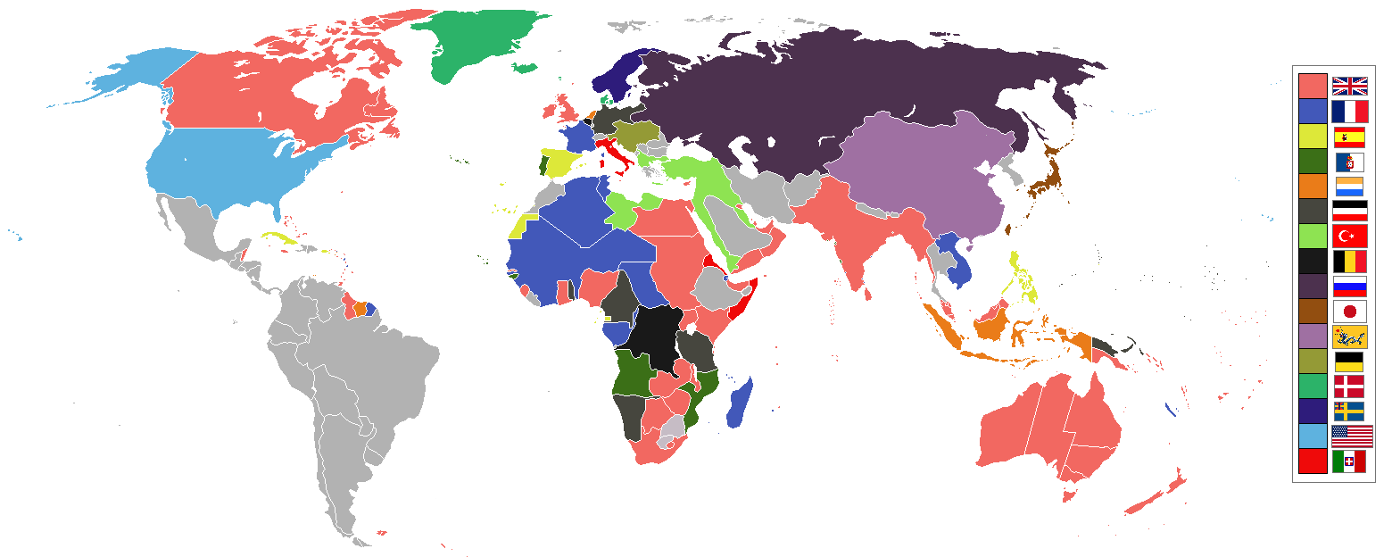
World empires and colonies 1898, (just before the Spanish–American War, Boxer Rebellion and Boer War), derived from Image:BlankMap-World-WWI.PNG
Tiếng Việt
Français
Empires et colonies du monde 1898, (juste avant la guerre hispano-américaine, la révolte des Boxers et la guerre des Boers, dérivée de Image:BlankMap-World-WWI.PNG).
عربي
مستوحاة من Image:BlankMap-World-WWI.PNG
中文 (繁體)
中文 (简体)
Deutsch
Italiano
Bahasa Indonesia
Imperium dan koloni di dunia pada tahun 1898 (sebelum Perang Spanyol-Amerika, Pemberontakan Boxer dan Perang Boer).
Македонски
Империи и колонии во 1898 г., (веднаш пред Шпанско-американската војна, Боксерското востание и Бурската војна), создадено врз основа на Image:BlankMap-World-WWI.PNG
Nederlands
Wereldrijken en kolonies 1898, (net voor de Spaans-Amerikaanse oorlog, Boxer opstand en Boerenoorlog).
Polski
Imperia i kolonie świata w 1898, (przed wojną amerykańsko-hiszpańską, powstaniem bokserów i wojnami burskimi), na podstawie Image:BlankMap-World-WWI.PNG
Português
Русский
Українська
한국어
1898년 세계의 각 제국과 국가들을 나타낸 지도이다. (미국-스페인 전쟁, 의화단 운동, 보어 전쟁 전의 상황이다.)
日本語
עברית
gurupletos
See also
| Maps of world history | |
| BC | |
|
| |
| AD |
1 · 50 · 100 · 200 · 250 · 300 · 400 · 500 · 700 · 750 · 820 · 900 · 1200 · 1500 · 1556 · 1648 · 1700 · 1750 · 1815 · 1859 · 1871 · 1914 · 1935 · 1954 · 1989 · 2000 · |
|
Maps of colonization history | |
|
see also: Eastern Hemisphere only maps template (1300BC-1500AD) | |
| (this template: · view · discuss ) | |
授權條款

|
已授權您依據自由軟體基金會發行的無固定段落、封面文字和封底文字GNU自由文件授權條款1.2版或任意後續版本,對本檔進行複製、傳播和/或修改。該協議的副本列在GNU自由文件授權條款中。http://www.gnu.org/copyleft/fdl.htmlGFDLGNU Free Documentation Licensetruetrue |
| 此檔案採用創用CC 姓名標示-相同方式分享 3.0 未在地化版本授權條款。 | ||
| ||
| 已新增授權條款標題至此檔案,作為GFDL授權更新的一部份。http://creativecommons.org/licenses/by-sa/3.0/CC BY-SA 3.0Creative Commons Attribution-Share Alike 3.0truetrue |
| 註解 InfoField | 該圖片含有註解:在維基媒體共享資源上查看註解 |
Capitanía General de Filipinas
說明
9 6 2006
image/png
檔案歷史
點選日期/時間以檢視該時間的檔案版本。
| 日期/時間 | 縮圖 | 尺寸 | 使用者 | 備註 | |
|---|---|---|---|---|---|
| 目前 | 2021年11月8日 (一) 09:16 | 1,560 × 624(45 KB) | Randomastwritter | jubaland | |
| 2019年7月3日 (三) 07:24 | 1,560 × 624(40 KB) | Insider | the border between East Africa Protectorate and Italian Somaliland per User talk:Insider#File:World 1898 empires colonies territory.png | ||
| 2019年1月31日 (四) 07:18 | 1,560 × 624(40 KB) | Insider | Arkticheskiy Institut Islands, Izvestiy TSIK Islands, Kirov Islands, Sverdrup Island, Russky Island, Uyedineniya Island, Vize Island and Ushakov Island also is terra nullis at 1898 | ||
| 2019年1月30日 (三) 10:34 | 1,560 × 624(40 KB) | Insider | In 1898, Grumant, Jan Mayen Island, Severnaya Zemlya, Franz Josef Land, Wrangel island was terra nullius. Fixed Aleutian and Solovki islands. | ||
| 2018年8月6日 (一) 15:56 | 1,560 × 624(45 KB) | Lord Obvious | |||
| 2016年4月12日 (二) 12:04 | 1,560 × 624(45 KB) | The- | Minor fixes | ||
| 2016年4月11日 (一) 21:59 | 1,560 × 624(45 KB) | The- | Minor fixes | ||
| 2016年4月11日 (一) 21:52 | 1,560 × 624(44 KB) | The- | More accurate map | ||
| 2014年8月3日 (日) 02:59 | 1,554 × 628(41 KB) | Alvin Lee | Correcting the boundaries of Russia and China | ||
| 2012年10月23日 (二) 18:36 | 1,554 × 628(62 KB) | Franco310397 | Spanish presence in Micronesia (Oceania) included in the Captaincy General of the Philippines. In the Caroline Islands and the Mariana Islands. |
檔案用途
全域檔案使用狀況
以下其他 wiki 使用了這個檔案:
- af.wikipedia.org 的使用狀況
- als.wikipedia.org 的使用狀況
- am.wikipedia.org 的使用狀況
- an.wikipedia.org 的使用狀況
- ar.wikipedia.org 的使用狀況
- av.wikipedia.org 的使用狀況
- az.wikipedia.org 的使用狀況
- ba.wikipedia.org 的使用狀況
- bg.wikipedia.org 的使用狀況
- bn.wikipedia.org 的使用狀況
- bs.wikipedia.org 的使用狀況
- ca.wikipedia.org 的使用狀況
- ceb.wikipedia.org 的使用狀況
- ce.wikipedia.org 的使用狀況
- cs.wikipedia.org 的使用狀況
- da.wikipedia.org 的使用狀況
- de.wikipedia.org 的使用狀況
- de.wiktionary.org 的使用狀況
- el.wikipedia.org 的使用狀況
- en.wikipedia.org 的使用狀況
檢視此檔案的更多全域使用狀況。
詮釋資料
此檔案中包含其他資訊,這些資訊可能是由數位相機或掃描器在建立或數位化過程中所新增的。若檔案自原始狀態已被修改,一些詳細資料可能無法完整反映出已修改的檔案。
| 水平解析度 | 47.24 dpc |
|---|---|
| 垂直解析度 | 47.24 dpc |
| 檔案修改日期時間 | 2019年7月3日 (三) 07:23 |