File:1947_Zhonghua_Minguo_Quantu.png
From Wikipedia, the free encyclopedia
原本檔案 (3,044 × 2,000 像素,檔案大細:13.79 MB ,MIME類型:image/png)
| 描述1947 Zhonghua Minguo Quantu.png |
中文(简体):1947年出版的中华民国地图和外蒙古地图。图中的南海诸岛的名称仍使用旧称。1947年中华民国地图,此图中注明「外蒙古已经我国承认其独立」。此图中南海四沙仍然沿用旧名。
English: Map of the Chinese Republic and Outer Mongolia published in 1947. The names of the South China Sea Islands (Nanhai Zhudao) in the map still used old names. At the top of the map in 1947, which indicates that Outer Mongolia has been recognized for independence by the government of the Republic of China, and show the border between China and Mongolia. |
||||
| 日期 | |||||
| 來源 | https://www.nansha.org.cn/maps/3/1947_ROC_Map.jpg | ||||
| 作者 |
This file is lacking author information.
|
||||
| 許可 (重用呢個檔案) |
|


Captions
1947
image/png
14,457,441 字節
2,000 像素
3,044 像素
檔案歷史
撳個日期/時間去睇響嗰個時間出現過嘅檔案。
| 日期/時間 | 縮圖 | 尺寸 | 用戶 | 註解 | |
|---|---|---|---|---|---|
| 現時 | 2019年5月7號 (二) 02:18 | 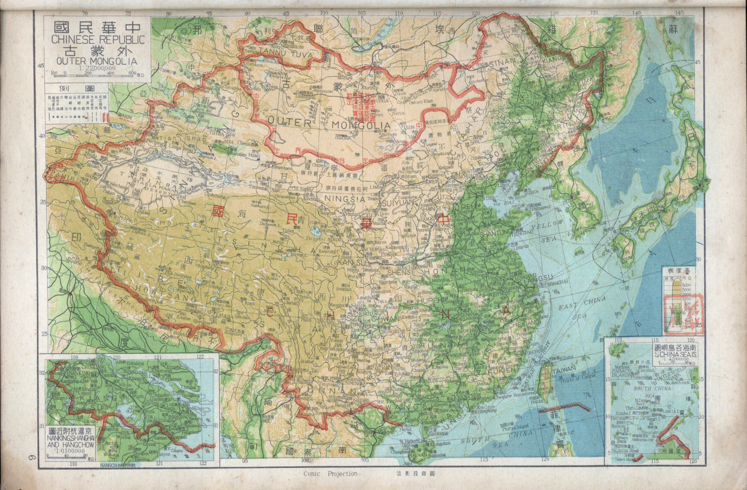 | 3,044 × 2,000(13.79 MB) | Tm | Reverted to version as of 12:27, 6 May 2008 (UTC) |
| 2019年5月7號 (二) 00:12 |  | 1,600 × 1,119(3.35 MB) | Aerbaniya | edit | |
| 2008年5月6號 (二) 12:27 |  | 3,044 × 2,000(13.79 MB) | Shibo77 | 中文说明: 为1947年出版的中华民国地图和南洋群岛图。图中的南海诸岛的名称仍使用旧称。1947年中华民国地图,此图中注明外蒙古已经被民国政府批准独立。此图中南海四沙仍然沿用旧名。 {{P |
檔案用途
以下嘅1版用到呢個檔:
全域檔案使用情況
下面嘅維基都用緊呢個檔案:
- ca.wikipedia.org嘅使用情況
- de.wikipedia.org嘅使用情況
- en.wikipedia.org嘅使用情況
- en.wiktionary.org嘅使用情況
- es.wikipedia.org嘅使用情況
- fr.wikipedia.org嘅使用情況
- id.wikipedia.org嘅使用情況
- ja.wikipedia.org嘅使用情況
- ko.wikipedia.org嘅使用情況
- mnw.wiktionary.org嘅使用情況
- no.wikipedia.org嘅使用情況
- sv.wikipedia.org嘅使用情況
- th.wikipedia.org嘅使用情況
- www.wikidata.org嘅使用情況
- zh.wikipedia.org嘅使用情況
Metadata
呢個檔案有額外嘅資料。佢應該係數碼相機或者掃描器整出來嘅。如果佢整咗之後畀人改過,裏面嘅資料未必同改過之後相符。
| 橫解像度 | 118.11 dpc |
|---|---|
| 直解像度 | 118.11 dpc |
| 檔案更動日期時間 | 2004年6月1號 (二) 22:56 |
| 用過嘅軟件 |
|