Washington Metro
Rapid transit system serving the Washington metropolitan area / From Wikipedia, the free encyclopedia
Dear Wikiwand AI, let's keep it short by simply answering these key questions:
Can you list the top facts and stats about Washington Metro?
Summarize this article for a 10 year old
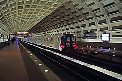
The Washington Metro, often abbreviated as the Metro and formally the Metrorail,[4] is a rapid transit system serving the Washington metropolitan area of the United States. It is administered by the Washington Metropolitan Area Transit Authority (WMATA), which also operates the Metrobus service under the Metro name.[5] Opened in 1976, the network now includes six lines, 98 stations, and 129 miles (208 km) of route.[6][7]
Metro serves Washington, D.C., as well as several jurisdictions in the states of Maryland and Virginia. In Maryland, Metro provides service to Montgomery and Prince George's counties; in Virginia, to Arlington, Fairfax and Loudoun counties, and to the independent city of Alexandria. The system's most recent expansion, which is the construction of a new station (and altering the line), serving Potomac Yard, opened on May 19, 2023. It operates mostly as a deep-level subway in more densely populated parts of the D.C. metropolitan area (including most of the District itself), while most of the suburban tracks are at surface level or elevated. The longest single-tier escalator in the Western Hemisphere, spanning 230 feet (70 m), is located at Metro's deep-level Wheaton station.[8]
In 2023, the system had a ridership of 136,303,200, or about 506,600 per weekday as of the first quarter of 2024, making it the second-busiest heavy rail rapid transit system in the United States, in number of passenger trips, after the New York City Subway, and the fifth-busiest in North America.[9] In June 2008, Metro set a monthly ridership record with 19,729,641 trips, or 798,456 per weekday.[10] Fares vary based on the distance traveled, the time of day, and the type of card used by the passenger. Riders enter and exit the system using a proximity card called SmarTrip.


