Top Qs
Timeline
Chat
Perspective
Kargilik County
County in Xinjiang, China From Wikipedia, the free encyclopedia

Remove ads
Kargilik County[4][5] (Uyghur: قاغىلىق ناھىيىسى), also known as Yecheng County (Chinese: 叶城县), is a county in southwest of the Xinjiang Uyghur Autonomous Region and is under the administration of the Kashgar Prefecture. It contains an area of 28,600 km2. To the north, the county borders Makit County. To the east, the county borders Guma County (Pishan) in Hotan Prefecture. To the west, the county borders Yarkant County, Poskam County and Taxkorgan Tajik Autonomous County. In the south, the county has a border of more than 80 km (50 mi) with Pakistan and India administered areas of Kashmir.[2]

.png)


Remove ads
History
In 1975, future Chinese Communist Party Deputy Committee Secretary of the Xinjiang Uyghur Autonomous Region Zhu Hailun was sent to Kargilik County in the Down to the Countryside Movement.[6]
Geography
The northern part of the county is in the Taklamakan Desert and the southern part of the county is in the Kunlun Mountains. Mazar Pass is located in the southern part of the county.
Climate
Administrative divisions
Summarize
Perspective
Kargilik County contains 6 towns and 15 townships.[2][9][10]
Remove ads
Economy
Kargilik County's economy is based on agriculture and animal husbandry. Agricultural products include wheat, corn and cotton, as well as pomegranates, yellow pears, walnuts, and dried apricots. Industries include construction, machinery, electronics, and food processing. The county is known for the 'Kargilik Banximao Sheep' (叶城半细毛羊).[13]
Demographics
In 1997, Uyghurs made up 93% of the population of the county and Han Chinese made up 6% of the population.[3]
As of 2015, 490,417 of the 519,962 residents of the county were Uyghur, 23,408 were Han Chinese and 6,137 were from other ethnic groups.[14]
As of 2018[update], Uyghurs made up 91% of the population of the county.[15]
As of 1999, 90.78% of the population of Kargilik (Yecheng) County was Uyghur and 8.18% of the population was Han Chinese.[16]
Remove ads
Transportation
Historical maps
Historical English-language maps including Kargilik:
 Map including Kargilik (labeled as Kargalik) (1917)
 Map including Kargilik (labeled as YEH-CH'ENG (KARGHALIK)) and surrounding region from the International Map of the World (AMS, 1966)
 Map including Kargilik (labeled as Yeh-ch'eng (Karghalik)) (ACIC, 1969)

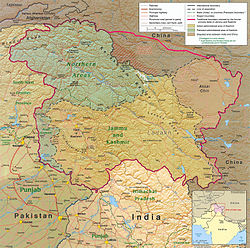 The southern part of Kargilik County includes territory ceded to China by Pakistan but claimed by India
_p61_PLATE19._SINKIANG_(14597194848).jpg)


Remove ads
See also
Notes
- Locals in Xinjiang frequently observe UTC+6 (Xinjiang Time), 2 hours behind Beijing.
- From map: "The representation of international boundaries is not necessarily authoritative."
- From map: "The representation of international boundaries is not necessarily authoritative"
References
Wikiwand - on
Seamless Wikipedia browsing. On steroids.
Remove ads